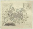
Map of the Ottoman Empire, Kingdom of Greece, and the russian provinces on the Black Sea
popis
Barev. 33 x 47 cm na listu 43 x 59 cm Měřítko [ca 1:5 900 000]. 6,8 cm = 250 english statute miles (015°32´04" v.d.--051°40´46" v.d./048°12´36" s.š.--028°08´58" s.š.)
- instituce / organizační jednotka
- Mapová sbírka Přírodovědecké fakulty UK v Praze
- podsbírka
- Mapová sbírka
- typ sbírky
- Mapy
- alternativní název
- Illustrated London News. April 21, 1877
- autor předmětu
- Dower, John
- datum vydání
- 1876
- jazyk dokumentu
- Angličtina
- lokalita/místo vzniku
- Spojené království Velké Británie a Severního Irska, Londýn
- materiál
- Papír
- původ
- Razítko BEC.
- inventární číslo
- 001570898
podobné předměty
-
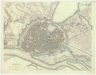 Mapová sbírka Přírodovědecké fakulty UK v PrazeHamburg
 -
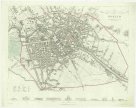 Mapová sbírka Přírodovědecké fakulty UK v PrazeBerlin
 -
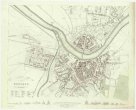 Mapová sbírka Přírodovědecké fakulty UK v PrazeDresden
 -
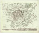 Mapová sbírka Přírodovědecké fakulty UK v PrazeMunich
 -
 Mapová sbírka Přírodovědecké fakulty UK v PrazeGeneva
 -
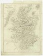 Mapová sbírka Přírodovědecké fakulty UK v PrazeA map of Scotland
 -
 Mapová sbírka Přírodovědecké fakulty UK v PrazeThe island of Antego
 -
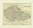 Mapová sbírka Přírodovědecké fakulty UK v PrazeBohemia & Moravia.
 -
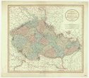 Mapová sbírka Přírodovědecké fakulty UK v PrazeA new map of Bohemia and Moravia